Britain's newest long-distance path opens up some of England's most dramatic and least crowded coastlines. The King Charles III England Coast Path, a 2,700-mile route encircling the entire English shoreline, nears completion this year. Travel writers recently explored five lesser-known sections combining dramatic scenery with rich historical layers.
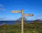
The journey begins in Northeast England. A circular walk around Lindisfarne covers four miles of this tidal island off Northumberland, where medieval priory ruins punctuate windswept moorland. The route captures both the spiritual history and raw coastal beauty that defines this remote region. Moving south, the Budle Bay to Bamburgh stretch spans five miles, passing hidden beaches and the iconic Norman fortress of Bamburgh Castle perched on volcanic rock.
These sections represent exactly what distinguishes the King Charles III path from established trails like the South West Coast Path. Rather than concentrating walkers on crowded hotspots, the route guides travelers through quiet stretches of working coastline, rural villages, and archaeological sites often missed by standard tourism circuits.
The path's completion marks a significant shift in British hiking accessibility. For decades, gaps in coastal access meant walkers navigated private land or followed inland detours. The finished path guarantees continuous public rights of way from Berwick-upon-Tweed in the north to Exmouth in Devon. Many sections open within the next 12 months.
Travel planning becomes straightforward with designated camping options, coastal hotels, and village pubs positioned throughout. Daily distances range from four to ten miles, making the route suitable for casual walkers tackling sections rather than thru-hikers attempting the full 2,700 miles in one expedition. The Northumberland sections mentioned offer spring and early autumn as ideal windows, with milder weather and fewer crowds than summer months.
The King Charles III path represents a democratic