# Aerial Photography Reveals Western Australia's Hidden Desert Beauty
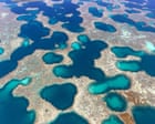
Photographer Martine Perret captures the raw majesty of Western Australia's remote interior through a five-year series of aerial images that expose landscapes few travellers ever witness firsthand. Her photographs reveal the Abrolhos Islands, Gascoyne region, and Wheatbelt areas from above, transforming salt flats, ancient riverbeds, and coastal ecosystems into visual narratives of geological time and environmental fragility.
The aerial perspective exposes what ground-level travel cannot. Salt flats stretch across the landscape in surreal palettes of white, pink, and ochre, reflecting light in ways that seem almost otherworldly. Ancient riverbeds carved over millennia tell stories of water movement across land now predominantly dry. The Gascoyne region, one of Western Australia's most sparsely populated zones, reveals itself as a land of dramatic contrast. Where water once flowed freely, only traces remain. Yet these traces define the topography that shaped Aboriginal cultures, colonial settlement patterns, and modern conservation efforts.
The Abrolhos Islands, located roughly 60 kilometres off the mid-west coast near Geraldton, appear as an archipelago of ecological significance. The waters surrounding these islands support unique marine biodiversity that remains largely unexplored by mainstream tourism. Perret's work documents these ecosystems at a scale that emphasises both their beauty and their vulnerability to climate change and human activity.
This photography series carries dual weight. Awe meets urgency. The images invite travellers to consider these regions not merely as distant destinations but as places requiring thoughtful stewardship. For those planning trips to Western Australia, these images reframe what "outback travel" means. Beyond the red deserts of Uluru and the beaches of Perth lies another Australia. The Gascoyne region offers minimal infrastructure. No major airlines fly directly into the heartland. Travellers typically base themselves in towns like Carnarvon or Denham and arrange four-wheel-drive tours, helicopter charters, or small-aircraft flights to see the landscape that Perret documents.
Budget considerations matter here. Helicopter tours over the Gascoyne region and Abrolhos Islands run between AUD 300 to 800 per person depending on flight duration and operator. Accommodation in Carnarvon ranges from modest motels at AUD 100-150 nightly to farmstays and eco-lodges offering more immersive experiences. The Wheatbelt, closer to Perth and more accessible by car, costs considerably less to explore.
Perret's work participates in a broader travel trend: aerial photography reshaping destination perception. Just as drone footage and satellite imagery changed how people see familiar places, professional aerial documentation influences travel decisions. Visitors now seek experiences that match these visual narratives. They want to see salt lakes and geological formations from perspectives previously reserved for pilots and geographers.
The environmental message embedded in Perret's series resonates with conscious travellers. Western Australia's midwest faces pressure from resource extraction, agricultural expansion, and climate impacts. Photography that documents these landscapes serves as both artistic achievement and conservation advocacy. Travellers who engage with these images often become more invested in sustainable tourism practices, supporting local Indigenous guides and conservation initiatives.
For Australian domestic travellers and international visitors seeking authentic outback experiences beyond the mainstream circuit, Western Australia's midwest offers unmatched visual drama. Perret's aerial documentation provides both inspiration and documentation of landscapes that demand attention now.