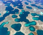
Photographer Martine Perret has captured aerial images of Western Australia's midwest region, revealing landscapes formed over millennia. The images showcase ancient riverbeds, expansive salt flats with striking colors, and unique marine biodiversity across the Abrolhos Islands, Gascoyne, and Wheatbelt areas.
Perret's photo series spans five years of aerial documentation. The work presents the land at scales that convey both natural grandeur and environmental urgency. Salt flats reflect vivid colors when viewed from above, while ancient riverbeds display the geological carving that shaped the terrain over thousands of years.
The Abrolhos Islands, located off Western Australia's coast, form part of the documented region. The Gascoyne area, known for its coastal and inland features, features prominently in the collection. The Wheatbelt, an agricultural region inland, rounds out the geographic scope of Perret's five-year project.
Aerial photography transforms how viewers understand landscape scale and formation. From above, salt flats and riverbeds become visible as continuous systems rather than isolated features. This perspective reveals patterns and colors invisible from ground level. Perret's work documents these formations while underscoring environmental conditions across the midwest.
The images exist within a broader context of aerial landscape photography. Similar work has documented other Australian regions, including Lake Eyre, also captured from above to reveal rare water patterns and environmental conditions.
Perret's ongoing series presents Western Australia's midwest as a region of geological and ecological significance. The five-year documentation captures how natural systems shape the landscape through water, salt, and time.