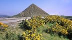
China clay mining transformed 35 square miles of Cornish landscape into a surreal terrain of white peaks and turquoise lagoons. Now new trails are opening this industrial heritage zone to walkers and cyclists.
The "Cornish Alps" near St Austell began in 1746 when Plymouth chemist William Cookworthy identified china clay deposits. By 1910, Cornwall produced roughly 50% of the world's china clay, about one million tonnes annually, exporting three-quarters of output. The clay became known as "white gold" and appeared in toothpaste, cosmetics and other products.
For every tonne of clay extracted, up to nine tonnes of waste remained behind, creating at least 100 pale pyramid-shaped peaks. Some pits filled with water, forming turquoise lagoons similar to glacial lakes. Swimming in these flooded pits is dangerous and forbidden because they reach roughly 50 yards deep with up to 48 yards of china clay underneath the surface.
In 2025, Imerys, the French corporation owning the land, opened 21 miles of new footpaths, bringing the trail network to 38 miles total. Many paths open to cyclists and horse riders too. These permissive paths link to larger Clay Trails connecting to Par Beach and Luxulyan Valley along the National Cycle Network. Access is free and generally year-round, though walkers should stay on marked trails near active kaolin pits and processing sites.
The region's most famous reclaimed pit now houses the Eden Project with its indoor rainforest and 30 acres of gardens. At Dubbers pit, over 100,000 native trees were planted in late 2024, one of south-west England's largest tree-planting schemes. Up to four miles of new paths wind through woodland and heathland home to red deer, dormice, jack snipe and little ringed plover.
Mining continues generating an estimated £40 million annually for the local economy, with decades of reserves remaining.